
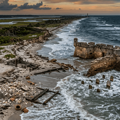
Florida’s coastline holds thousands of years of human history. Beneath its sands, wetlands, riverbanks, and barrier islands lie traces of Indigenous communities, colonial settlements, maritime industries, historic cemeteries, and early American towns. Together, these places form one of the richest cultural landscapes in North America. But many of them are increasingly at risk from a growing and unavoidable threat: water.
Across Florida, rising seas, stronger storm surge, and more frequent tidal flooding are reshaping the coastline. Some archaeological sites are slowly eroding away. Historic buildings that survived for more than a century are now flooding repeatedly during storms. In many areas, the question is no longer whether these cultural resources will be affected, but how quickly the damage will occur and what can still be protected.
A new statewide study offers one of the clearest pictures yet of this growing problem. Using advanced spatial analysis and flood modelling, researchers mapped Florida’s archaeological and historic resources against projections for sea level rise, hurricane storm surge, and high tide flooding. The results reveal the scale of the challenge facing one of America’s most historically significant coastlines.
A coastline shaped by history
Florida’s coast has attracted human settlement for nearly 14,000 years. Indigenous communities established villages, shell mounds, fishing camps, and ceremonial sites long before European arrival in the 1500s. Over centuries, Spanish forts, ports, churches, lighthouses, cemeteries, and waterfront towns became part of the state’s cultural identity.
Today, many of these sites remain concentrated along the coast and near rivers and bays. According to the Florida Master Site File, the state contains more than 253,000 recorded archaeological and historic resources, including thousands of historic structures and archaeological sites located in low-lying coastal areas.
These places are culturally important, but they also support local economies. Heritage tourism contributes billions of dollars to Florida each year, attracting visitors to places such as St. Augustine, Pensacola, and the Florida Keys.
Three types of flooding, one growing threat
The study focused on three major flooding hazards that increasingly affect Florida’s coast.
The first is storm surge, the sudden rise of ocean water pushed inland during hurricanes. Storm surges can flood entire communities within hours and often cause catastrophic damage.
The second is sea level rise. Unlike storm surge, sea level rise happens gradually, but its effects are long-lasting and cumulative. Even small increases in average sea level can permanently inundate low-lying land and intensify other forms of flooding.
The third is high tide flooding, sometimes called “sunny day flooding.” These floods can occur without storms simply because sea levels have risen high enough for tides to overflow into streets, wetlands, and coastal properties.
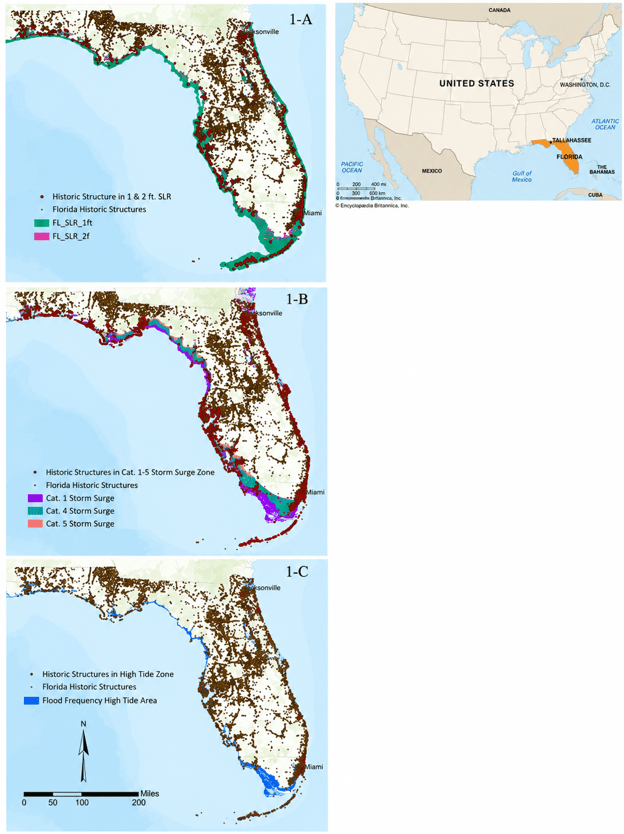
To examine these risks, researchers combined flood projections from the National Oceanic and Atmospheric Administration with Florida’s cultural resource inventory. They analysed hurricane storm surge scenarios for Category 4 and 5 storms, along with one-foot and two-foot sea level rise projections and high tide flooding models.
More than 67,000 historic structures and over 10,500 archaeological sites fall within projected Category 4 storm surge zones. Under Category 5 scenarios, those numbers rise even further. Even a one-foot rise in sea level could place more than 4,500 archaeological sites at risk, while high tide flooding already threatens thousands of sites across the state (Figure 1) [Fig.1]
Importantly, many of these locations do not require a major hurricane to flood. Some are already experiencing regular tidal flooding during unusually high tides.
Why some sites are more vulnerable than others
Not all heritage sites face the same level of danger. The study found that geography plays a major role in determining vulnerability.
Researchers combined flood modelling with field observations from the Florida Public Archaeology Network Heritage Monitoring Scouts programme, a citizen-science initiative in which trained volunteers monitor vulnerable cultural sites.
The data showed that archaeological sites located beside open coastlines face the highest rates of deterioration. Sites near rivers and channels are also highly vulnerable because river flooding and erosion often combine with coastal flooding during storms.
Interestingly, sites along sheltered bays appeared to experience fewer impacts, likely because they are less exposed to direct wave energy.
The Florida Keys provide a clear example. Sites facing open ocean conditions often show far greater erosion and flood damage than sites protected behind islands or bays. Even the orientation of a site, whether it directly faces open water, can influence how quickly it deteriorates.
As coastlines evolve and waters rise, preserving cultural heritage is not simply about protecting sites; it is about safeguarding the stories, identities, and knowledge that help communities navigate an uncertain future.
—Sorna Khakzad Knight
Cultural loss is also economic loss
Although archaeology may seem like a specialised field, the implications extend far beyond historians, archaeologists and scientists. Historic places are deeply connected to tourism, local identity, education, and community life. Florida’s historic preservation sector generates billions of dollars annually through tourism and related economic activity.
Furthermore, when historic buildings flood repeatedly or archaeological sites erode into the sea, communities lose more than physical structures. They lose connections to local history, cultural identity, and economic opportunity.
One example highlighted in the study is the historic First Baptist Church in Port St. Joe. Built in 1923, the church survived for nearly a century before severe flooding during Hurricane Michael led to irreversible damage and eventual demolition.
The researchers identified many other historic structures in similar high-risk zones that could face comparable futures if flood risks continue increasing.
Using science to guide difficult decisions
One of the study’s most important contributions is practical rather than theoretical. The research provides a framework that can help decisionmakers prioritise limited resources. Protecting every vulnerable site across Florida is not realistic. Instead, agencies and communities need ways to identify which sites are most significant, most vulnerable, or most urgently in need of documentation and protection.
The study demonstrates how flood models and spatial analysis can support those decisions. By identifying where multiple flood hazards overlap with culturally important sites, planners can better target monitoring, emergency preparedness, conservation efforts, and long-term adaptation strategies.
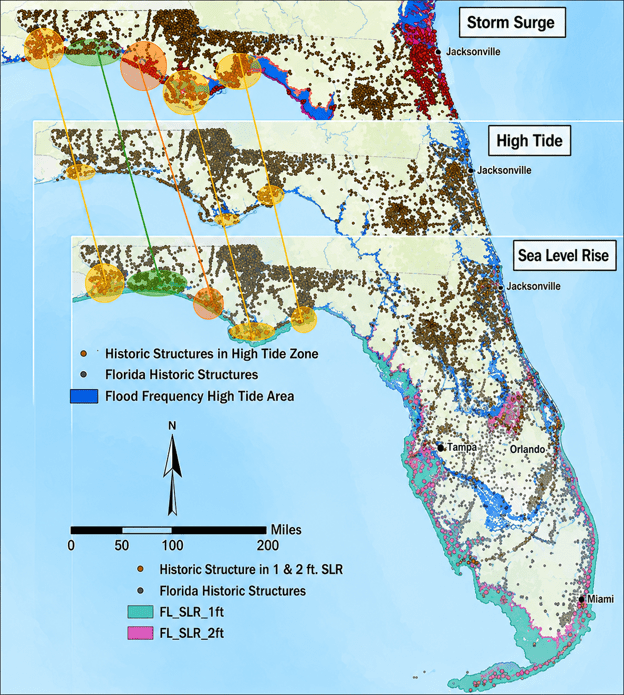
Researchers tested this approach in Northwest Florida, where areas around Escambia Bay, Apalachicola, and the Big Bend region showed particularly high concentrations of at-risk cultural resources. The study also examined places such as Fort Pickens and the historic Pensacola train depot, now home to the Florida Public Archaeology Network, which flooded during Hurricane Sally in 2020 (Figure 2).
A race against time
The researchers acknowledge that flood modelling still has limitations. Models can predict where flooding may occur, but not always the exact level of damage individual sites will experience. Wind, erosion, wave action, and repeated flooding can affect sites in different ways depending on local conditions. However, the overall trend is clear. Florida’s cultural heritage is becoming increasingly vulnerable as climate pressures intensify.
The study’s broader message extends beyond Florida. Similar coastal heritage threats are emerging worldwide, from Europe to the Pacific Islands. The methods developed here could help other regions identify vulnerable cultural landscapes before irreversible losses occur.
For now, Florida still has time to document, monitor, and protect many of its most important historic places. But that window is narrowing.
The coastline is changing. The challenge now is deciding what can still be saved before the tide rises further.
Reference
Khakzad, S., & Clark, B. (2026). A multi-factor flood impact assessment approach towards evaluating Florida’s coastal cultural resources. Journal of Island and Coastal Archaeology. https://doi.org/10.1080/15564894.2025.2587026